
This is a report on an issue of the Garmin GPSMAP 67 in which we observe a huge drift of the location it indicates when the device is stationary (i.e. does not move). It seems to occur more often when satellite reception conditions are not optimal. Typical real life situations in which this occurs are when you pause during a hike in the forest or during Geocaching. Next picture shows the coordinate as recorded by the device overnight when placed stationary at the window. At the start the location is indicated correctly (green symbol). Then the logged coordinate starts wandering throughout the village where I live. A power cycle of the device immediately resolves the problem: the coordinate indicated jumps back to where it is supposed to be. This indicates it is a software error that can be resolved.
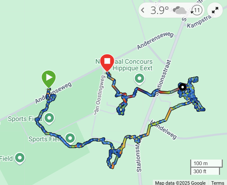
This image has been taken from the Garmin Connect website. An investigation has been made into the problem. This document reports on the findings.
Device
| Device | Garmin GPSMAP 67 |
| Serial number | 7QH027772 |
| Firmware version | 8.90 (but also observered in 9.1 and 7.6) |
| GPS Firmware version | 11.02 |
| GPS setting | Multi-glnss, Multi band |
| Recording | Interval, one record every second |
| Activity | Hiking |
| Expedition mode | Never |
What we expect from a GPS…
The Garmin support site defines following about GPS drift:
‘GPS drift, in the most practical sense, is the difference between your actual location and the location recorded by a GPS receiver. Since consumer-grade GPS receivers (such as the ones Garmin makes) are not 100% accurate, this can cause a difference between your actual location and your recorded location.‘
‘The GPS location accuracy of Garmin outdoor watches is around 3 meters (10 feet), 95% of the time. This means, at any given time, your watch will save your location within 3 meters of your actual location.’
This makes sense and is normal behavior of a GPS: it shows where you are with a reasonable error.
Note: given the better antenna we expect the GPSMAP 67 to perform at least as good, if not better than the wearables.
Finding
Summary
- The coordinate that is indicated by the GPSMAP 67 drifts over time when the device is stationary (i.e. no movement). Deviations are far more than expected: deviations of >100 m have been observed multiple times.
- The problem occurs more frequently when the conditions for satellite reception are not optimal, like in the forest under trees. On one occasion the drift was 12 m after a 20 minutes stop in the forest.
- The problem is reproducible: the device was placed stationary in house against the window, lying on its back.
- The problem is immediately resolved on a power cylce (switching the device off and on again): the indicated coordinate jumps to the ‘real’ position.
- Movement improves the situation, when the coordinate has drifted: the coordinate indicated converges to the real location; however, occasionally a residual error remains
Ideal and less ideal conditions
When the device has clear sky view and is upright (antenna vertically pointing up) we usually find good precision. However occasionally we see the drift even under these ideal conditions.
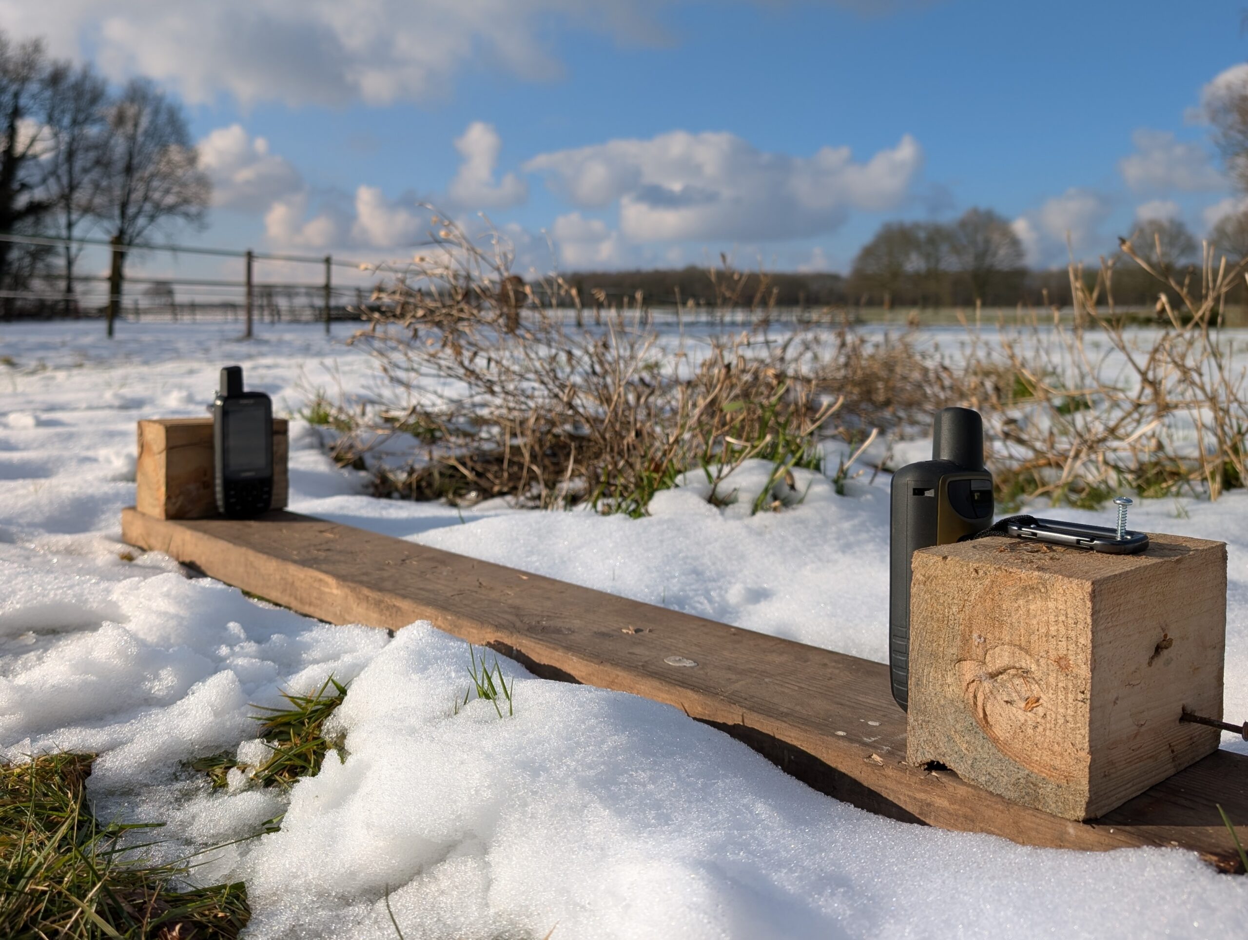
Next graph shows a comparison between the GPSMAP 66sr and the GPSMAP 67 over 24 hours in the setup shown on the photo. The red circle indicates the circle in which 95% of the measurements reside. The GPSMAP 66sr shows expected behavior, the GPSMAP 67 shows the drifting.
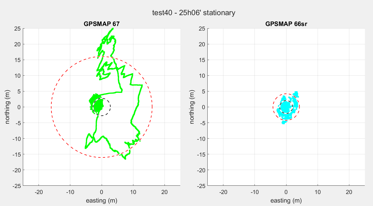
In this example the radius of the circle in which 95% of the measurements reside is larger than 15 meters, whereas it should be ~3 m according to Garmin.
When conditions are less ideal, like resting in the forest or placing it inside behind a window, coordinate drift all the time. The problem is reproducible.
Firmware version
The intial test took place with latest firmware to date (25-01-2025): FW 8.90 (GPS FW: 11.02). Firmware was downgraded to FW 7.60 (GPS FW: 2.46). Also here we see the error. Issue has not been resolved with FW 9.10.
Effect of moving: improvement but with residual error
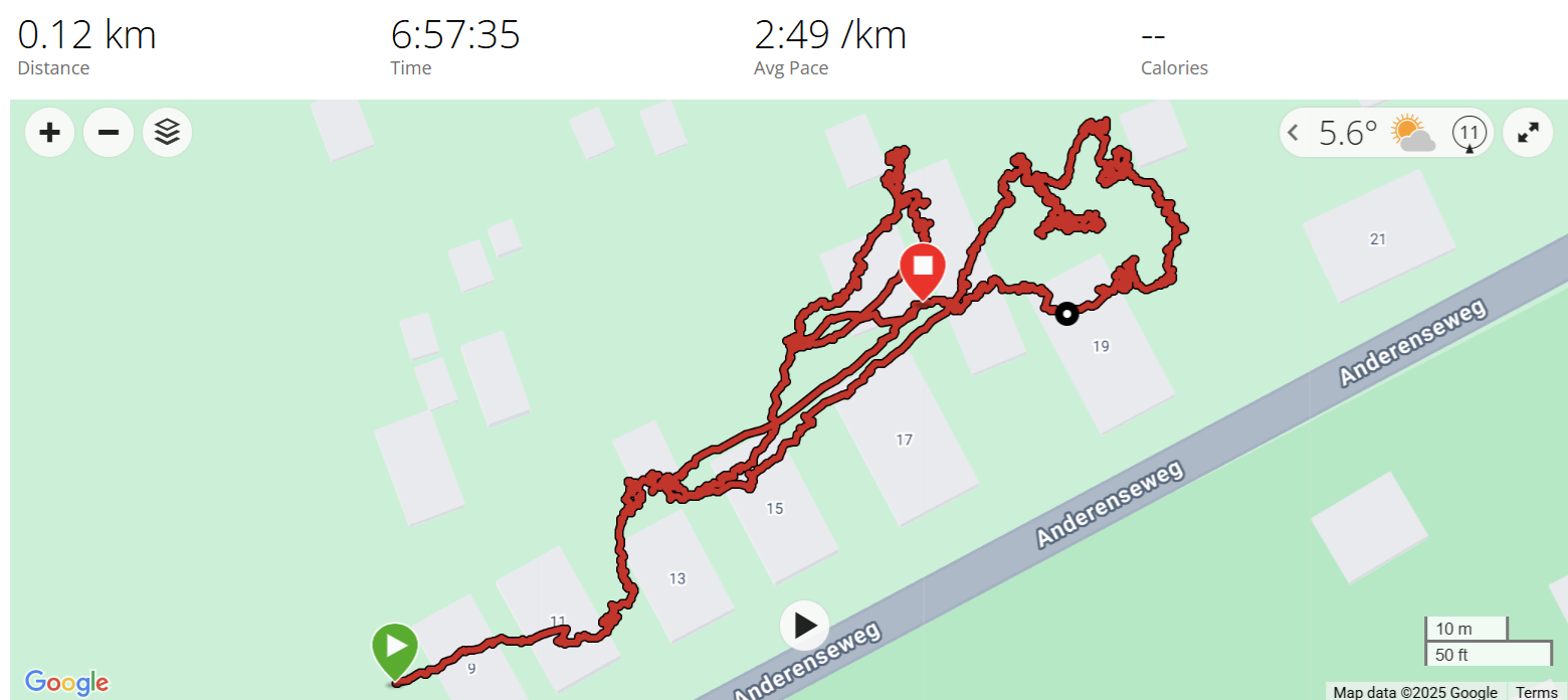
When starting to move, the error seems to reduce. In next example we left 3 GPSses unattended for 3h40′ inside the house, behind the window and then took it outside and walked them in NNW direction and back again. The Fenix 7 and Edge 1040 were used as reference. As you can see the coordinate indicated by the GPSMAP 67 drifts, but after movement converges to where it is supposed to be.
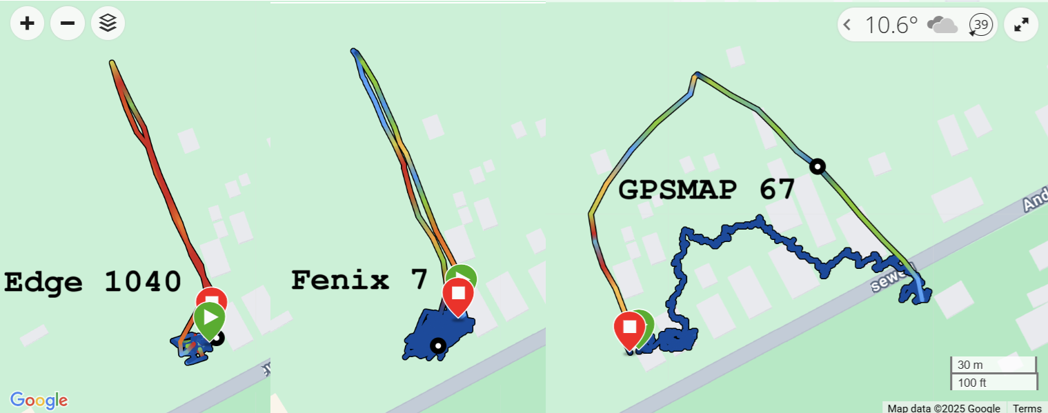
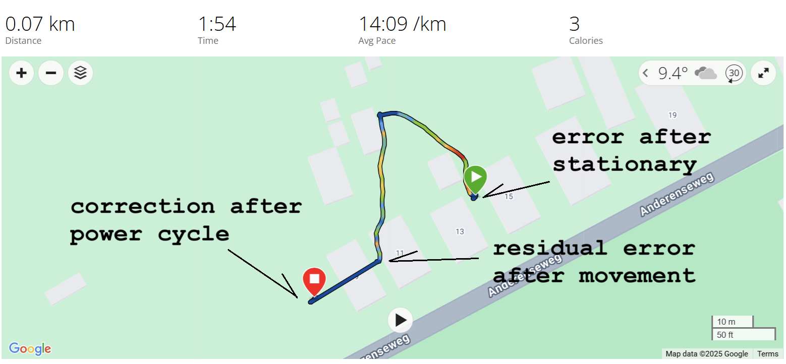
However, occasionally we observe residual error after movement, which only disappears on a power cycle. This is shown in next image for FW 7.60. The track is started after a period of stationary placement, so it indicates the error. Then the device was moved outside, reducing the error. Finally the device was power cycled and logging resumed. This resulted in the indicated coordinate to jump to the actual position.
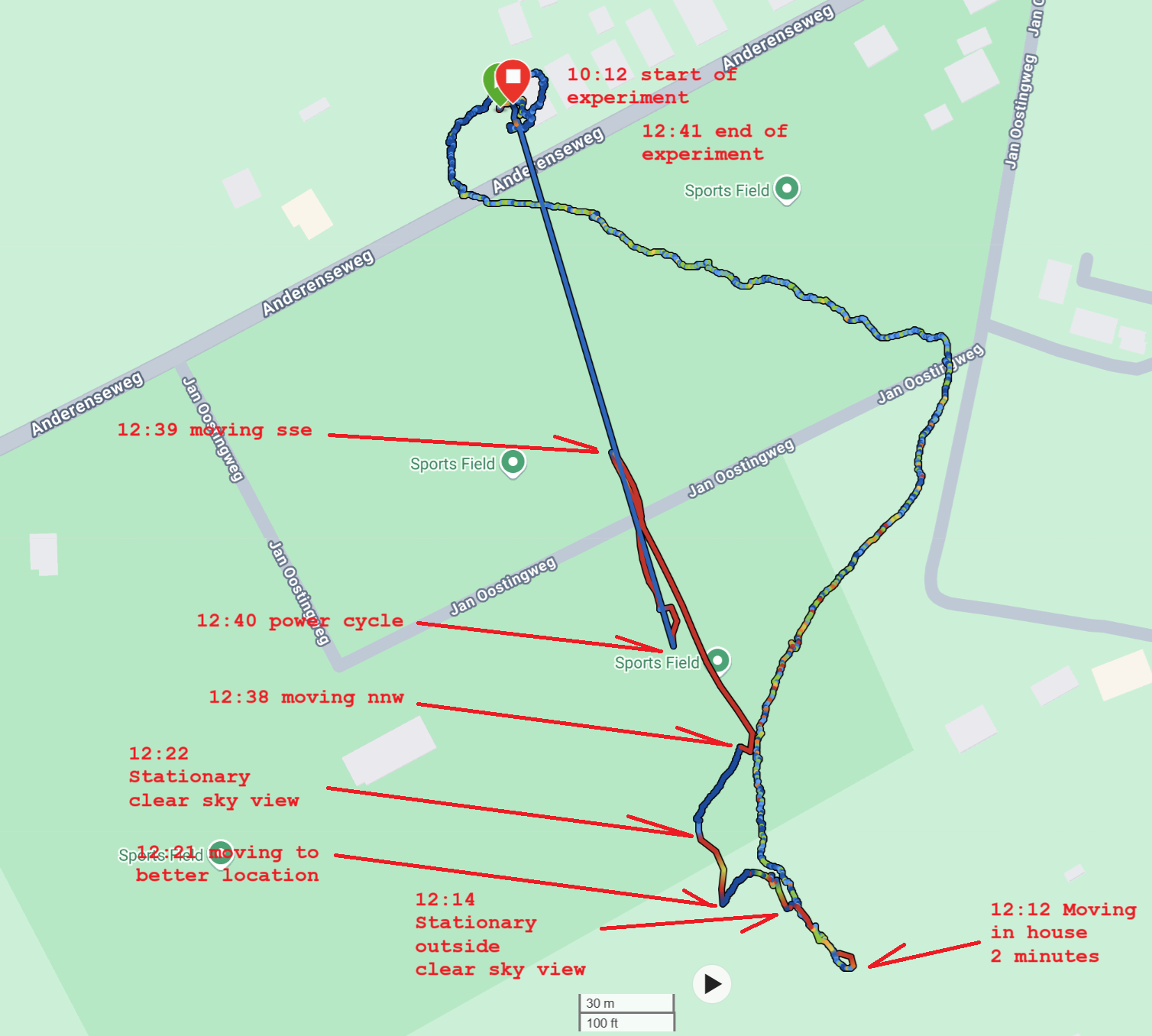
In next example several things were tried (moving, getting the device a clear sky view, moving, moving back) after the device went berzerk, but nothing got it right again except from a power cycle. Since an error remains of hundreds of meters, the device is totally unreliable.
GPS only vs Multi-GNSS
Effect has been observed in Multi-GNSS but also in GPS Only mode (FW 7.60)
Waypoint logging
When the device indicates the wrong location it also affects the waypoints logged with the ‘Mark’ button.
Interpretation and solution?
Warning: This section is purely guessing!
We have reason to believe that the GPSMAP 67 takes into account the signal of the accelerometers and/or the digital compass when estimating the current position based on previous position (next to GPS based location of course): when standing still under unobstructed sky, try to move the device to and fro 80 cm repeatedly while holding it in your hand: you immediately introduce an error in the position of ~10m which cannot be explained by bad satellite reception. A similar mechanism is applied in car navigation: if there is no satellite reception like in tunnels, the GPS uses speed an direction to estimate the position. This is called ‘dead-reckoning‘.
This feature makes the device extremely accurate and able to register the slightest movements. However, this feature seems to take over when satellite reception is less than ideal: it results in dead-reckoning error. In dead-reckoning, based on a known position (fix), next position is calculated using speed and direction. When not comparing to real position, the position error increases. Probably due to sensor noise the course is rather random.
The solution would be not to rely on this feature entirely but always take GPS position into account: if deviation between dead-reckoning and GPS position is too large (> 3 m?), use the GPS position. This is what appears to take place when you power cycle the device: it takes the GPS position.
In my opinion it should be possible to disable the feature.
Conclusion
Though the GPSMAP 67 is a marvelous device and probably one of the most precise devices on the market, it shows an abnormal (larger than expected) deviation of the indicated coordinate when the device is stationary. When not under ideal conditions (unobstructed sky view, vertical position) this deviation is repeatable and starts immediately. Though movement improves the recorded coordinate, occasionally residual error remains.
The fact that the problem immediately resolves when a power cycle is executed indicates that the device knows the proper GPS position. Therefore the problem can easily be solved.
These deviations have been reported on the Garmin Forum (see: GPS about 30m off) which indicates it is not an incident or one device instance malfunctioning.
This problem renders the device unusable for practical use like Geocaching. You cannot trust the coordinate it indicates, especially when you pause for a moment under conditions where the sky is obstructed or the device is not exactly upright.
The problem has been reported to Garmin Support Netherlands and is known under references Q#:1001450 and Ref:29213587K0. They respond:
Ik heb uw probleem besproken met ons technisch team en ik wil u door verwijzen naar de onderstaande link:
GPS Drift and Environmental Factor Impact on GPS Accuracy for Garmin Outdoor Handheld Products
The problem has been reported to Garmin Support US (Ref:29213587K0, Q#:1010250). They respond:
While we appreciate the information you have reported it looks like you have previously reported it to us and a case was created where they said you were experiencing GPS drift due to the less than optimal position (such as indoors) for the extended period of time. This is by design as mentioned previously.
[If it is ‘by design’, please explain! What is a GPS worth when you cannot rely the position it indicates? Especially remaining error after standing still…]
Any outside influence on the accuracy of your Garmin device is an environmental factor and can cause a degraded GPS signal. Environmental factors can vary by the ability of the device to receive an uninterrupted GPS radio signal from the satellites. Using the device inside even if at the window can be an obstacle. You can think of environmental factors as things that interrupt the signal path of a GPS signal from the satellite to your device.
The longer your handheld has to receive uninterrupted GPS signals from the area in which you are located the more accurate your location information will be. It is highly recommended that you give your device an opportunity to get a solid GPS fix from multiple satellites and you will want to be outside with a good view of the sky. The signal bounces off the house or other items when used inside.
It appears Garmin don’t (want to) understand the problem or don’t know their own devices…